
Making a valid planning application
In order for us to process your planning application efficiently we require a certain standard of submission. This guidance note has been prepared to assist you in ensuring the information submitted is of a suitable quality.
Also please see the guidance note on the national standards for the validation of planning and other related consents in Scotland, which is published by Heads of Planning Scotland.
Application Form
We recommend you use the online application service as this guides you through all of the appropriate sections. Please ensure that all sections of the application form are completed even if the answer is N/A (not applicable).
You must ensure that the following items have been completed to the appropriate standard:
- Applicant details;
- Agent details (if any) are fully completed, please provide an e-mail address as this allows us to process your application electronically;
- Clearly give the full postal address of the property, or if the site has no address describe the location and give map coordinates to allow easy identification. Descriptions for a site are best when they relate to another location/address, e.g. “Land to the north of 10 Main Street”;
- Proposal description should be detailed including all works that require permission e.g “Erection of dwellinghouse and detached double garage, including formation of access”. If a change of use is required then please give details of the existing and proposed uses, including use classes if you can. Please ensure that if your application is for temporary permission that the details of this are given, e.g. “temporary permission for 5yrs” or “use as a caravan site April to October” (please contact us for advice on appropriate proposal descriptions); and
- The declaration at the end of the form must be signed and dated.
Land Ownership Certificate
When submitting a paper application, please note that the Land Ownership Certificate is a separate document which is downloaded as part of the application pack. This must be submitted with all applications.
You are legally required to identify if you are the owner of the land and if the land is part of an agricultural holding. You are not required to own the land to make an application. However, if you are not the owner of the land then you are legally required to try to identify who is and provide them with a notification that you are making this application. You must provide their details on the form and give us a copy of the notice sent to them. If the owner cannot be identified you must indicate what steps you took in your attempts at identification and your application will require to be advertised in the local press.
Planning Fee
Planning Fees are set out in legislation and must be submitted with your application. Payment of fees can be made online when you submit an electronic application; over the telephone; by cheque through the post or by cash at either of our office in Balloch.
If your application has been submitted online then there is a fee calculator facility to assist in ensuring the correct fee is submitted. However we recommend that if your proposal is not straightforward then you should contact us to calculate an accurate fee prior to submission. Please see our Planning Fees page to assist in identifying the appropriate fee for your application. Listed Building and Conservation Area Consents do not require a fee.
Advertisement Fee
In addition to the planning fee your application may require an advertisement fee which pays for an advert in the local press. In order to minimise delay in the processing of your application we suggest that you automatically submit the required £160 with your application to cover the cost of this advertisement as it will be refunded if not required.
Location Plan
The precise location of the application site should be made clear. Please ensure your plan has:
- A north point;
- At least 2 named roads (we are aware that in some rural locations this will not be possible);
- Surrounding buildings or show the site in relation to neighbouring land; • The scale should preferably be 1:1250;
- A red line indicating the application site (please see notes to follow); and
- A blue line indicating any other surrounding land within the same ownership of the applicant.
Site Plan
The site plan should show the site as it currently stands. Please ensure your plan has:
- A north point;
- The scale should be 1:200 or 1:500;
- Details of current buildings on site;
- Details of current access and parking provision;
- A red line indicating the application site (please see notes to follow); and
- Any trees currently on site indicating whether they are to be retained, cut or felled.
Red Lines
 Red lines should encompass the complete ‘planning unit’ to which the application relates. All householder applications should have the red line follow the garden boundary no matter how minor the works are.
 Any land in the same ownership of the applicant should be outlined in blue, if it is not classed as garden curtilage.
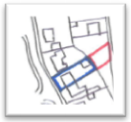 If the application is to change the use of a piece of land to bring it into your garden ground then the red line should only go round the part that requires the change of use, with the existing garden outlined in blue.
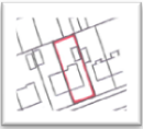
 If the application is for the erection of a dwellinghouse the red line should follow the full extent of the proposed garden boundary including any required access.
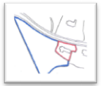
 Hotels and other business buildings almost always have a clearly identifiable ‘planning unit’ this is what the red line should show. This planning unit usually includes the access and parking provision, any immediate garden ground or outdoor seating area, any other buildings associated with the use of the main building (e.g. Leisure Suite or storeroom).
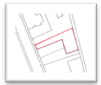
 Some public buildings, like this example within a town square, do not have any directly associated outside land and therefore the red line should surround only the building.
Other Plans/Drawings
If you submit your application online then no paper copies are required however for larger more complex developments we would be grateful if you can provide at least 2 paper copies and/or CD’s to assist with community council consultation and public access. If you are submitting a paper application then one copy is sufficient unless, as stipulated above, the application is large or complex and at least 2 paper copies should be provided.
Please ensure that you have:
- A drawing number on all plans, if any alterations are made to these drawings through the process of your application this drawing number needs to be revised (e.g. Rev A, Rev B etc.);
- Produced your drawings to an appropriate scale, generally for elevations and floor plans this scale should be 1:100 or 1:50. Please note for online applications we require notation indicating the correct print size;
- A north point;
- Existing drawings are required to show the details of the building or site as it currently stands. Floor plans and elevations should be provided for most applications even if the current buildings on site are to be demolished;
- Proposed elevations, floor plans and roof plans showing details of the proposed development. All new work should be in colour and partial elevations should be avoided;
- Site/Block Plan should be at a scale of 1:500 and should be the ‘proposed site plan’. This should include the complete red line site indicating access and parking arrangements, any hard-surfacing, trees and landscaping proposals;
- Section elevations can be useful to explain complicated building arrangements or new window/door details;
- New buildings may require streetscape drawings/photomontages showing them in relation to adjacent buildings; Streetscapes will be required for infill developments in Conservation Areas;
- Cross Sections and contours are required when changes to ground levels are proposed;
- Photographs are extremely beneficial for Listed Buildings and Conservation Areas. They can also be used for small scale householder developments (e.g. applications for flue vents), if they are dimensioned and marked up as proposed, to replace elevation drawings; and
- Down takings must be coloured or hatched particularly relevant to conversion applications
Additional Information
Further information may be required as part of your application. This guidance highlights the most common documents/reports that can be required in certain circumstances (please note this list is by no means exhaustive).
Supporting Statement – Most applications would benefit from a statement of justification for the proposal. This could include the reason for development, any proposed arrangements for access by the public, opening hours, uses of the building, how it relates to its environment and how it will operate in practical terms. Not all applications ‘require’ the above information but it may be deemed useful for the planning officer considering your application if they were provided. The more information you can provide on submission, the more likely your proposal will be understood by ourselves and the public and could lessen the likelihood that the application will be delayed due to this information being requested at a later date.
Design Statement – Developments within sensitive areas such as Conservation Areas, National Scenic Areas and within the curtilage of a Category ‘A’ Listed Building require this document to be submitted prior to validation (depending on the proposal). Design statements are useful tools for explaining the design principles and concepts of the development and should include an explanation of the policy or approach adopted, describe the steps taken to appraise the context of the site and state what, if any, consultation has been undertaken on issues relating to design principles and concepts. Even if this is not ‘required’ we would advise that all submissions for more complex developments submit this type of information. Further guidance can be found in our Sustainable Design Guidance (pdf) and PAN 68: Design Statements.
Sustainability Checklist – All applications should include a completed Sustainability Checklist (Word doc) to show how sustainable development principles have been factored into the design process, in accordance with Policy SUSDEV1 of the Local Plan.
Flood Risk Assessment – If your development is within or adjacent to an indicative flood risk zone we advise that you submit a flood risk assessment with your application. If not provided with your application it can hold-up the consultation process and subsequently the determination date. You can view the Indicative River and Coastal Flood Map on SEPA’s website.
Tree Survey – Where the development proposed will affect or be close to mature trees, a survey of the trees is required. Details of how this should be undertaken can be found in our Planning Advice Leaflet on Trees and Survey Requirements (pdf).
Species and/or Habitat Survey – Please submit a survey for all protected species and habitats that might be affected by the proposed development. Details of survey requirements can be found in our Planning Advice Note: Biodiversity and planning (pdf).
Bat Survey – This is particularly relevant for proposals involving redundant buildings or reroofing proposals and can cause delay if omitted given bat hibernation periods. If you are in doubt about whether you need a Bat Survey please contact us for advice.
Structural Survey – This should be submitted with proposals for the conversion of redundant buildings. Sustainable Urban Drainage System (SUDS) details – It is preferred that this information is submitted initially to assist with consultations and assessment of your proposal.
Foul drainage proposals – In order to obtain advice from Scottish Water or SEPA regarding mains connection, septic tanks or treatment plants etc. details are required on submission.
Environmental Impact Assessment – For developments that fall within Schedule I of the Environmental Impact Assessment (Scotland) Regulations 2011 an Environmental Statement is required to be submitted with your application. Developments that fall within Schedule II (regardless of their size) may require the submission of an Environmental Statement, this can be determined through a request for a screening opinion from us. Details of these Schedules and the EIA process can be found in our Planning Advice Note: Environmental Impact Assessment (pdf)
‘ICNIRP’ Declaration– Where your proposal relates to a telecommunication installation and antennae is being installed as part of an electronic communications network this form must be submitted with the application.
Further advice
This guidance has been produced to provide advice regarding the information required to make a valid planning application. Please do not treat this advice as comprehensive. Different applications require different types of information and this leaflet can only provide broad general advice. The specific information required for your particular development can only be properly assessed on submission of the application. We recommend that you make use of our free pre-application service if you are unsure what details will be required and what guidance applies to your proposal.
Please contact the planning team at planning@lochlomond-trossachs.org or Tel: 01389 722024 for further advice.