
Local Development & Land Use Plan – Call for Land, Sites & Ideas
A Call for Land, Sites and Ideas was open from January to April 2026 to help elicit views on how land could be used and developed in the National Park in future. The Call for Land, Sites and Ideas is now closed.
This is part of the informal engagement process of developing the new Local Development and Land Use Plan.
We invited people to put forward land, sites and ideas to help inform the Local Development and Land Use Plan. This could include opportunities for development, land management, nature restoration, climate action, or other ways land could be used or protected.
At this stage, we have captured sites submitted through the Call for Land Sites and Ideas, sites identified in registered Local Place Plans where clear boundaries and proposed uses were provided and existing Local Development Plan sites that have not been developed.
All ideas, priorities and aspirations identified in Local Place Plans are being captured to help inform the new Plan. However, not all content is shown as sites on the published map at this stage. Sites have been mapped where clear boundaries and proposed uses were provided, while other content has been summarised in our Place Profiles. All additional Local Place Plan content will be considered as we develop the new Plan’s spatial development and land use strategy.
Local Place Plans registered throughout the preparation of the Plan will also be considered in the same way as those captured to date, with sites, ideas and priorities informing the development of the new Plan as appropriate.
The Call was open to everyone and specifically of interest to: landowners, developers, farmers, land and estate managers, businesses, community groups, and individuals.
Suggested Sites
The suggested sites received can be viewed on our interactive map and a summary of ideas, specifically received through the Call for Land, Sites and Ideas process are noted below.
Additional spatial information, that supported our Evidence Report is also available to view in our Evidence Base and Strategic Flood Risk Assessment mapping resources.”
Ideas received
National Park‑wide ideas, specifically received through the Call for Land, Sites and Ideas process reflect a range of suggestions relating to accessibility, sustainable transport, housing, and recreational infrastructure. These include expanding accessible parking, strengthening active travel networks, and considering ways to incorporate sustainable transport principles within future policy. Suggestions were also received on reviewing visitor experience policies, exploring a more permissive housing in the countryside policy, and identifying specific sites that could support affordable housing through government funding or developer contributions.
Recreation ideas include suggestions to preserve or enhance boating facilities, introduce additional slipways around Loch Lomond, and further develop the strategic network of walking and cycling routes. Climate resilience, nature‑based approaches, and community benefit are highlighted as essential cross‑cutting principles.
Area focused CLSI ideas are summarised below:
West Loch Lomond – Summary of ideas:
- Ideas focus on settlement boundaries and water access improvements.
- Adjustments to the existing settlement boundary was suggested for Luss with additional suggestions including identifying potential settlement boundaries around Aldochlay, Muirlands and Rossdhu.
East Loch Lomond – Summary of ideas:
- Ideas focus on settlement boundaries, facilities, and transport management
including new toilets and Changing Places provision and formally designating Balmaha as a settlement with a defined boundary; extending the Croftamie settlement boundary to include Pirniehall; and a new Park and Ride facility to manage visitor pressures and improve sustainable access in the wider East Loch Lomond area. - Enhancing water‑based access and facilities focused on Milarrochy Bay and Rowardennan.
Strathard & Trossachs – Summary of ideas:
- Ideas relate to community led housing, flood mitigation, and long distance access routes
including potential collaboration between the community, landowners and RSHA to explore sites that could support affordable, energy efficient housing with options for community involvement or ownership. - Ideas from Aberfoyle include an overflow or slipway tunnel to help address flooding on Lochard Road.
- A long distance aqueduct path associated with Loch Katrine, aimed at enhancing recreation networks and visitor experience, is also suggested.
Callander & Strathearn – Summary of ideas:
- The key idea focuses on improving facilities at Station Road Car Park, including retaining it as a car park but enhancing it with EV charging, improved 24/7 accessible toilets and showers, motorhome waste disposal, and a dedicated campervan area.
- This reflects a wider theme of supporting sustainable tourism infrastructure and better visitor management.
Strathfillan & Glen Dochart – Summary of ideas:
- Ideas focus on refining settlement boundaries, dark sky designation, and active travel connectivity.
- Suggestions include amending the St Fillans settlement boundary, establishing a Dark Sky Park in the North of the National Park, and expanding active travel routes to improve local and regional connectivity.
Cowal – Summary of ideas:
- There were no ideas submitted through the CLSI process within the Cowal area of the National Park.
Information drop-in sessions
Dates and venues for the drop-in sessions
Balloch, National Park Authority Headquarters: Wednesday 21st October, 3pm – 7pm
Arrochar, Three Villages Hall: Tuesday 27th October, 3pm – 7pm
Killin, McLaren Hall: Thursday 29th October, 3:30pm – 7pm
Callander, Callander Youth Project Trust: Monday 2nd November, 3pm – 7pm
Drymen, Drymen Village Hall: Wednesday 4th November, 5pm – 8pm
Aberfoyle, Memorial Hall: Tuesday 10th November, 3pm-7pm
You do not need to attend the whole workshop and you don’t need to register to attend. You can just drop into the venue on the day, within the window advertised. National Park Authority staff will be there to chat with and answer any questions. We will also have maps showing the sites proposed in the local area, as shown in this map. The meeting in Arrochar will cover both Cowal and West Loch Lomond sites.
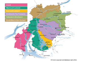
If you are unable to make it to one of these sessions you can comment on the sites and ideas submitted by completing a short feedback form.
Information gathered through this process will help inform the preparation of the Proposed Plan, which will then be published for a full public consultation in 2027, allowing communities, stakeholders and individuals to comment formally before the Plan is finalised in 2028.